


The Ultimate Guide to Driving The Alpine Loop

The Ultimate Guide to Driving The Alpine Loop Scenic Byway
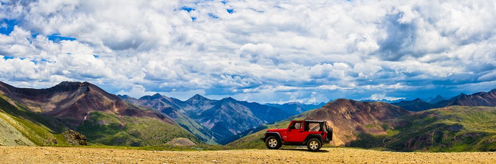
The Alpine Loop Scenic Byway, a network of four-wheel drive roads, is one of the most breathtakingly beautiful alpine drives in the world, connecting some of the most stunning scenery in the state of Colorado.
This rough, high-elevation route is not for the faint of heart; full of bumpy terrain with winding turns and steep drop-offs.
But for the adventurous offroad driver, the Loop’s views are more than worth it. If you’re looking for a breathtaking trip that will leave you with lasting Rocky Mountain memories, take the scenic route on the Alpine Loop.
What is the Alpine Loop?
The Alpine Loop Scenic Byway, aka “the Alpine Loop” (or just “The Loop,” to locals,) is a 60+ mile network of old 4×4 mining roads connecting the southern Colorado mountain towns of Lake City, Silverton, and Ouray.
The Loop connects two high-elevation mountain passes, Cinnamon Pass and Engineer Pass. Only 4 miles of the entire 60+ mile route (a small section in Lake City) are paved. The Loop tops out at an elevation of 12,800 ft on Engineer Pass, with much of the road above the tree line.
Over 100,000 people brave the Alpine Loop each summer, making it one of the most famous off-highway roads in the United States.
What kind of vehicle do you need for the Alpine Loop?
To traverse the full Alpine Loop, you’ll need a 4WD vehicle with high clearance. Many visitors choose to ride the Loop in an off-highway vehicle (OHV) specifically meant for rough travel.
If you don’t have a 4WD vehicle, 2WD and AWD cars with moderate clearance can still enjoy several scenic portions of the Alpine Loop, including Capitol City on the Engineer Pass side of the loop from Lake City, American Basin on the Cinnamon Pass side of the Loop from Lake City, and the Animas Forks ghost town from Silverton. These are still rough, unpaved drives, but possible in most passenger cars if you have some experience with rugged roads and take it slow.
Tips for driving the Alpine Loop
- The Alpine Loop usually opens by Memorial Day and closes by November. Keep an eye on the weather and check road conditions before you go. Check AlpineLoop.info for status, multi-county regulations, and more.
- Plan for an all-day adventure without cell service as there is no cell service on the Alpine Loop, except in Lake City, Silverton, and Ouray. The road is 64 miles, but with a speed limit of 15 mph it takes most people a minimum of 6 hours with stops. Start early in the day, expect mid-day thunderstorms, and plan to be back in town by dark for safety.
- Expect difficulties like rough terrain, driving close to cliff edges, and backing up on a downhill so others can pass. On most of the Loop, the road is only wide enough for one vehicle at a time.
- The road is busiest from 10am-4pm and in July, when wildflowers and temperatures are generally at their best.
- Slow down and see the mountains. It’s a scenic byway, not a highway, so the journey is the destination.
- Uphill traffic has the right of way, but use common sense. If you pass a convenient pullout when there’s a car coming, pull off and wait even if you have the right of way.
- If you’re traveling in a group, use hand signals to let other cars know how many more cars are behind you. Group vehicle size should be no larger than twelve. If traveling in a group of more than twelve vehicles, you should split up and give time and distance between your groups.
- For the easiest terrain, drive the Loop clockwise from Lake City or Silverton. That means you’ll climb the hardest part of the Loop, the switchbacks on Engineer Pass, instead of going down them, and you won’t be on the outside of the road during its steepest drop-offs.
Help Protect the Alpine Tundra: Stay the Trail
The otherworldly landscape above treeline needs our help. Alpine soil takes hundreds of years to form, and can take hundreds of years to recover if trampled or driven over by careless travelers. Stay on designated trails at all times to protect our incredible —and incredibly fragile— alpine landscape. As you travel the Alpine Loop, look for brown signs that designate the type of vehicles allowed in each area and obey any closures. Visit StayTheTrail.org to learn more.
If you pack it in, pack it out — even food scraps and poop! There are vault toilets located at several sites along the way, including the Grizzly Gulch trailhead and in the ghost town of Animas Forks, but there are no trash cans along the route.
ATV/OHV Routes and Restrictions
While ATVs and OHVs are allowed on the streets of Lake City, they are not allowed on any city street in Silverton, Ouray, or Telluride. Off-road vehicles are also only allowed on Highway 149 in Lake City through Lake City from the Friday before Father’s Day until September 30th through the OHV Highway Program. OHVs will be able to ride on Hwy 149 from CR 30 (MM 69.88) south of Lake City to the Ocean Wave Drive intersection (MM 72.11) on the northern end of Lake City. OHVs are not permitted to ride on any other areas of the highway at any time outside the boundaries or dates of the program. Learn more about the OHV Highway Program and rules and regulations here.
Must-See Stops Along the Alpine Loop
A trip on the Alpine Loop will spoil you silly with gorgeous scenery. Plan to take a full day to savor some of the best spots along the way.
The recommended and traditional start for the Alpine Loop starts in Lake City and goes clockwise, starting near Lake San Cristobal, the “lake” in Lake City and Colorado’s second-largest natural body of water. Fishing, kayaking, and paddleboarding are all popular activities here, and you could easily spend a day on the clear blue lake.
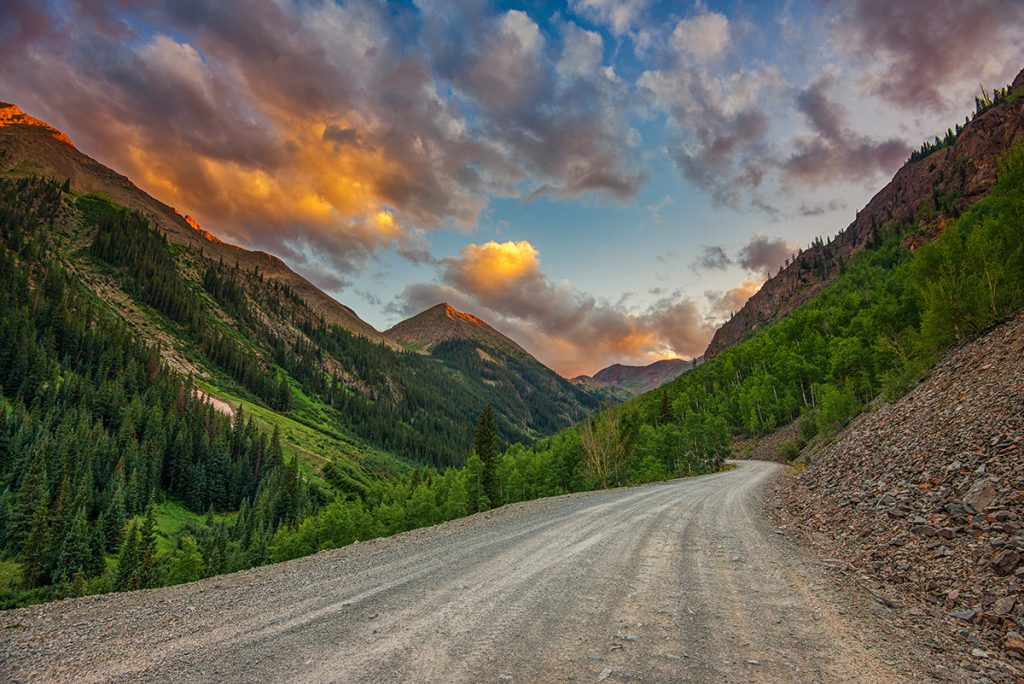
Past the lake, you’ll leave the pavement (and most of the people) behind. At about 8 miles in, you’ll see an overlook for the first ghost town, Sherman. This is a good place to stop, savor the scenery, and mentally prepare yourself for the first “shelf road,” or road cut directly into the cliff face of the day. Over the next few miles, the road winds its way along the rock face with your first glimpse of the Alpine Loop’s steep drop-offs. Keep an eye open for mining ruins and bighorn sheep clinging to the cliffs!
After this, the road enters a valley, Burroughs Park, where you will find the Silver Creek and Grizzly Gulch trailheads for the 14ers Handies Peak, Redcloud Peak, and Sunshine Peak. The next few miles of the road are filled with epic alpine views, mining history, and avalanche debris. Be sure to look behind you for dramatic views of Redcloud and Sundog Peaks.

Next stop, American Basin: one of the premier wildflower spots in Colorado each July. Stay on the trail and don’t disturb the fragile alpine soil, so flowers can continue to grow here for generations of Alpine Loopers to come.
The trailhead for Handies Peak, one of the shortest 14er summits, begins at American Basin as well. Crystal-blue Sloan Lake, just 2 steep miles up the trail, is also a popular destination in itself.
As you leave American Basin, flip that 4WD switch and let the excitement begin. Now, you begin to climb Cinnamon Pass. Ruins from the Tobasco mine will greet you as you gain elevation and leave the trees behind. Look down into the valley on your left to see the old tramway posts that ran ore from the mine to the mill.
At 12,600 ft, you’ll arrive at the often-snowy summit of Cinnamon Pass, which makes for a great photo op. In the next few miles, you’ll lose all the elevation you just gained and learn the joys of 4WD low as you bump your way down to Animas Forks.
Animas Forks is one of the best-preserved ghost towns in the United States. The town sprouted to support silver mining in the late 1800s, hosting a population of 450 at its peak, and was abruptly abandoned after the silver market crash of the 1890s.
At 11,000 feet, life was rough here to say the least. In the 1880s there was a 23-day blizzard that dumped 25 feet of snow, forcing the residents to dig tunnels between houses. The same forces of nature are still present today, as in 2019 when avalanches dumped over 100 feet of snow on the road and closed this part of the Alpine Loop until July.
Animas Forks, as the name suggests, is also a fork in the road. From there, it’s 12 bumpy miles into the town of Silverton, where you can grab lunch, browse the shops, or even spend the night.
Or, you can continue the Alpine Loop to Engineer Pass, the toughest —but perhaps the most scenic— part of the drive. Brave the grueling switchbacks to the top of Engineer Pass and you’ll be rewarded with unforgettable views of the San Juan Mountains from Oh! Point and Odom Point.
The actual summit of the pass is a quarter mile past Odom Point. You’ll pass through an expanse of alpine tundra called American Flats as the jagged 14ers Uncompahgre and Wetterhorn Peak tower above you. Stop for a panoramic photo: this is one of the best drive-up views in all of Colorado!
Now, you’re on the downhill stretch. It’s about 20 miles of rocky road back to where you started from here, with plenty of chances to glimpse any wildlife you missed on the way up. You’ll pass the Empire Chief mine, destroyed by an avalanche in 2008, and the sign for Whitmore Falls. You can take a quick walk to the overlook for the falls, or venture down a steep 1/10 mile trail to the bottom for a refreshing swim. It’s one of the best waterfalls on the Alpine Loop and one of the best swimming holes in the state.
The ghost town of Capitol City is next. It was founded in 1877 by George Lee, who dreamed of making this remote city the state capital of Colorado — but now, the photogenic abandoned post office is all that remains of Lee’s dream.
Past Capitol City, it’s relatively smooth sailing back to Lake City. You’ll pass Nellie Creek (the access road for climbing Uncompahgre Peak) just before coming into the ghost town of Henson. Henson is home to the Ute Ulay mine, the silver mine responsible for Lake City’s boom, with well-kept ruins and historical signs visible via a walking tour.
If you want to venture into a mine, visit the Hard Tack Mine in Henson for a safe, guided tour of an underground mining tunnel. You’ll end your journey in Lake City, 4 more miles down the road.
Congratulations: you completed the Alpine Loop! It’s time to celebrate, perhaps with an old-fashioned ice cream at San Juan Soda Co. or a local brew from the Lake City Brewing Company. Cheers to you for making it this far!
What to bring for a drive on the Alpine Loop
If you decide to brave the Alpine Loop, pack your vehicle like you’ll be camping overnight, even if you don’t plan to. In case of car trouble or bad weather, it may take several hours or even overnight before help can reach you. (Don’t be scared, but do be prepared!)
Don’t forget to bring:
- A full tank of gas.
- Extra food and water, enough for an unplanned overnight.
- Blankets, warm extra layers, and waterproof jackets for all members of the group.
- WAG bags (aka Go Anywhere Bags, Blue Bags, Biffy Bags). Bathrooms on the loop are limited and these bags will allow you to do the doo anywhere and pack it out to protect our backcountry and fragile tundra.
- A bag to pack out trash and used wag bags (trash cans are not available on the Loop).
- A paper map, like National Geographic Trails, Illustrated #141, or pre-downloaded digital maps, as there is no cell service on the Alpine Loop, except in Lake City, Silverton, and Ouray.
- A satellite messenger, like a Spot or a Garmin InReach. Cell service is not available on the Alpine Loop, except in Lake City, Silverton, and Ouray.
- A spare tire, jack, and air compressor.
- A camera and binoculars for spotting wildlife.
- A sense of adventure!
Whether you complete the entire Alpine Loop or just a small, scenic section, you deserve a celebratory mountain meal for your bravery. Check out one of Lake City’s delicious family-run restaurants for fresh burgers, pizza, ribs, ice cream, and more to end your day of adventure.
This blog was made possible through a grant from Visit Colorado.